


Etape 3 vers Côte Normande

lionelwalter
User

Length
76 km

Max alt
150 m

Uphill gradient
758 m
Km-Effort
86 km

Min alt
-3 m

Downhill gradient
820 m
Boucle
No
Creation date :
2018-04-18 00:42:14.189
Updated on :
2018-04-18 00:42:14.189
4h54
Difficulty : Medium

FREE GPS app for hiking
 SityTrail
IGN / Geographical institutes
SityTrail Plus
The world is yours!
About
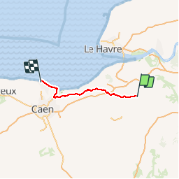
Trail Cycle of 76 km to be discovered at Normandy, Eure, Cormeilles. This trail is proposed by lionelwalter.
Description
De Cormeilles (Pays d'auge) à Plages débarquement Côte Normande
Positioning
Country:
France
Region :
Normandy
Department/Province :
Eure
Municipality :
Cormeilles
Location:
Unknown
Start:(Dec)
Start:(UTM)
309311 ; 5458138 (31U) N.
Comments