


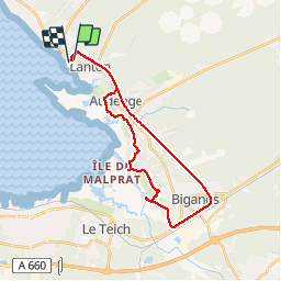
Lanton

csy95
User

Length
28 km

Max alt
23 m

Uphill gradient
198 m
Km-Effort
31 km

Min alt
0 m

Downhill gradient
202 m
Boucle
No
Creation date :
2018-08-26 10:57:44.846
Updated on :
2018-08-26 10:57:44.885
2h10
Difficulty : Easy

FREE GPS app for hiking
 SityTrail
IGN / Geographical institutes
SityTrail Plus
The world is yours!
About
Trail Cycle of 28 km to be discovered at New Aquitaine, Gironde, Lanton. This trail is proposed by csy95.
Positioning
Country:
France
Region :
New Aquitaine
Department/Province :
Gironde
Municipality :
Lanton
Location:
Unknown
Start:(Dec)
Start:(UTM)
654847 ; 4952182 (30T) N.
Comments