


Vallée de la Mérentaise

c.chehere
User
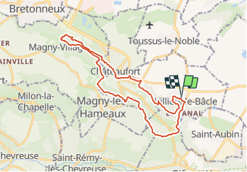

Length
16.9 km

Max alt
171 m

Uphill gradient
357 m
Km-Effort
22 km

Min alt
82 m

Downhill gradient
356 m
Boucle
Yes
Creation date :
2018-04-18 00:45:19.851
Updated on :
2018-04-18 00:45:19.851
4h43
Difficulty : Unknown

FREE GPS app for hiking
 SityTrail
IGN / Geographical institutes
SityTrail Plus
The world is yours!
About
Trail Walking of 16.9 km to be discovered at Ile-de-France, Essonne, Villiers-le-Bâcle. This trail is proposed by c.chehere.
Positioning
Country:
France
Region :
Ile-de-France
Department/Province :
Essonne
Municipality :
Villiers-le-Bâcle
Location:
Unknown
Start:(Dec)
Start:(UTM)
435538 ; 5397503 (31U) N.
Comments