


lac de l'ailette

DaVinci
User
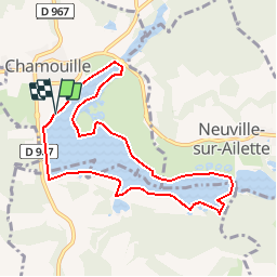

Length
8.1 km

Max alt
91 m

Uphill gradient
32 m
Km-Effort
8.5 km

Min alt
79 m

Downhill gradient
35 m
Boucle
Yes
Creation date :
2018-04-18 00:46:15.682
Updated on :
2018-04-18 00:46:15.682
1h37
Difficulty : Unknown

FREE GPS app for hiking
 SityTrail
IGN / Geographical institutes
SityTrail Plus
The world is yours!
About
Trail Other activity of 8.1 km to be discovered at Hauts-de-France, Aisne, Chamouille. This trail is proposed by DaVinci.
Positioning
Country:
France
Region :
Hauts-de-France
Department/Province :
Aisne
Municipality :
Chamouille
Location:
Unknown
Start:(Dec)
Start:(UTM)
548401 ; 5479785 (31U) N.
Comments