


lac de madine

DaVinci
User
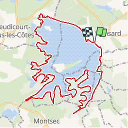

Length
33 km

Max alt
236 m

Uphill gradient
143 m
Km-Effort
34 km

Min alt
222 m

Downhill gradient
143 m
Boucle
Yes
Creation date :
2018-04-18 00:46:20.881
Updated on :
2018-04-18 00:46:20.881
6h30
Difficulty : Unknown

FREE GPS app for hiking
 SityTrail
IGN / Geographical institutes
SityTrail Plus
The world is yours!
About
Trail Other activity of 33 km to be discovered at Grand Est, Meuse, Nonsard-Lamarche. This trail is proposed by DaVinci.
Positioning
Country:
France
Region :
Grand Est
Department/Province :
Meuse
Municipality :
Nonsard-Lamarche
Location:
Unknown
Start:(Dec)
Start:(UTM)
701682 ; 5422949 (31U) N.
Comments