


Cires les Mello

Francine
User
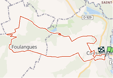

Length
12.7 km

Max alt
106 m

Uphill gradient
198 m
Km-Effort
15.4 km

Min alt
36 m

Downhill gradient
198 m
Boucle
Yes
Creation date :
2018-04-18 00:49:41.708
Updated on :
2018-04-18 00:49:41.708
3h20
Difficulty : Medium

FREE GPS app for hiking
 SityTrail
IGN / Geographical institutes
SityTrail Plus
The world is yours!
About
Trail Walking of 12.7 km to be discovered at Hauts-de-France, Oise, Cires-lès-Mello. This trail is proposed by Francine.
Description
Cires les Mello
Positioning
Country:
France
Region :
Hauts-de-France
Department/Province :
Oise
Municipality :
Cires-lès-Mello
Location:
Unknown
Start:(Dec)
Start:(UTM)
453485 ; 5457884 (31U) N.
Comments