


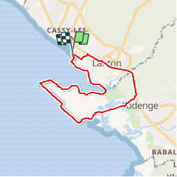
RandoLanton

csy95
User

Length
14.2 km

Max alt
13 m

Uphill gradient
62 m
Km-Effort
15.1 km

Min alt
-4 m

Downhill gradient
61 m
Boucle
Yes
Creation date :
2018-08-26 10:57:43.191
Updated on :
2018-08-26 10:57:44.185
3h20
Difficulty : Easy

FREE GPS app for hiking
 SityTrail
IGN / Geographical institutes
SityTrail Plus
The world is yours!
About
Trail Walking of 14.2 km to be discovered at New Aquitaine, Gironde, Lanton. This trail is proposed by csy95.
Positioning
Country:
France
Region :
New Aquitaine
Department/Province :
Gironde
Municipality :
Lanton
Location:
Unknown
Start:(Dec)
Start:(UTM)
654216 ; 4952216 (30T) N.
Comments