


Tour de l'esterel

rene06530
User
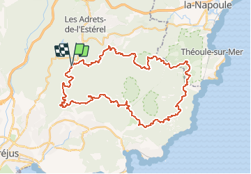

Length
45 km

Max alt
469 m

Uphill gradient
971 m
Km-Effort
58 km

Min alt
14 m

Downhill gradient
969 m
Boucle
Yes
Creation date :
2018-06-26 10:46:15.442
Updated on :
2018-06-26 10:46:15.442
3h46
Difficulty : Difficult

FREE GPS app for hiking
 SityTrail
IGN / Geographical institutes
SityTrail Plus
The world is yours!
About
Trail Mountain bike of 45 km to be discovered at Provence-Alpes-Côte d'Azur, Var, Fréjus. This trail is proposed by rene06530.
Description
Départ Malpey
Positioning
Country:
France
Region :
Provence-Alpes-Côte d'Azur
Department/Province :
Var
Municipality :
Fréjus
Location:
Unknown
Start:(Dec)
Start:(UTM)
322279 ; 4818215 (32T) N.
Comments