


BRIE TURY VRAI

UDGI54
User
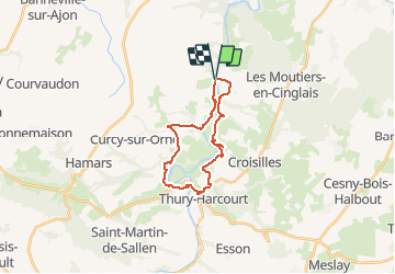

Length
19.8 km

Max alt
135 m

Uphill gradient
558 m
Km-Effort
27 km

Min alt
18 m

Downhill gradient
560 m
Boucle
Yes
Creation date :
2018-06-26 10:52:50.281
Updated on :
2018-06-26 10:52:50.281
--
Difficulty : Unknown

FREE GPS app for hiking
 SityTrail
IGN / Geographical institutes
SityTrail Plus
The world is yours!
About
Trail Walking of 19.8 km to be discovered at Normandy, Calvados, Montillières-sur-Orne. This trail is proposed by UDGI54.
Positioning
Country:
France
Region :
Normandy
Department/Province :
Calvados
Municipality :
Montillières-sur-Orne
Location:
Goupillières
Start:(Dec)
Start:(UTM)
685128 ; 5434215 (30U) N.
Comments