


savoie grangeat lac

coglais
User
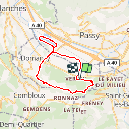

Length
12.2 km

Max alt
801 m

Uphill gradient
329 m
Km-Effort
16.6 km

Min alt
549 m

Downhill gradient
325 m
Boucle
Yes
Creation date :
2018-06-26 10:57:38.922
Updated on :
2018-06-26 10:57:38.922
1h30
Difficulty : Medium

FREE GPS app for hiking
 SityTrail
IGN / Geographical institutes
SityTrail Plus
The world is yours!
About
Trail Nordic walking of 12.2 km to be discovered at Auvergne-Rhône-Alpes, Upper Savoy, Domancy. This trail is proposed by coglais.
Positioning
Country:
France
Region :
Auvergne-Rhône-Alpes
Department/Province :
Upper Savoy
Municipality :
Domancy
Location:
Unknown
Start:(Dec)
Start:(UTM)
319986 ; 5085822 (32T) N.
Comments