


La Fayée par Charouille

rigol05
User
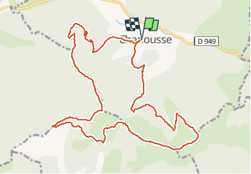

Length
13.6 km

Max alt
1288 m

Uphill gradient
712 m
Km-Effort
23 km

Min alt
779 m

Downhill gradient
711 m
Boucle
Yes
Creation date :
2018-06-26 11:15:44.528
Updated on :
2018-06-26 11:15:44.528
4h56
Difficulty : Difficult

FREE GPS app for hiking
 SityTrail
IGN / Geographical institutes
SityTrail Plus
The world is yours!
About
Trail Walking of 13.6 km to be discovered at Provence-Alpes-Côte d'Azur, Hautes-Alpes, Chanousse. This trail is proposed by rigol05.
Description
Sortie du 19/04/2018Itinéraire avec des pentes relativement raides surtout pour atteindre le sommet de la Fayée. Itinéraire peu balisé mais sur bon sentier.
Positioning
Country:
France
Region :
Provence-Alpes-Côte d'Azur
Department/Province :
Hautes-Alpes
Municipality :
Chanousse
Location:
Unknown
Start:(Dec)
Start:(UTM)
711651 ; 4914756 (31T) N.
Comments