


st andre

semaine
User
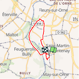

Length
9.2 km

Max alt
37 m

Uphill gradient
83 m
Km-Effort
10.3 km

Min alt
3 m

Downhill gradient
83 m
Boucle
Yes
Creation date :
2018-06-26 11:16:52.928
Updated on :
2018-06-26 11:16:52.928
2h23
Difficulty : Unknown

FREE GPS app for hiking
 SityTrail
IGN / Geographical institutes
SityTrail Plus
The world is yours!
About
Trail Other activity of 9.2 km to be discovered at Normandy, Calvados, Saint-André-sur-Orne. This trail is proposed by semaine.
Description
rando A
Positioning
Country:
France
Region :
Normandy
Department/Province :
Calvados
Municipality :
Saint-André-sur-Orne
Location:
Unknown
Start:(Dec)
Start:(UTM)
691186 ; 5443413 (30U) N.
Comments