


2018 avril 23

FLOCON
User

Length
13.2 km

Max alt
289 m

Uphill gradient
196 m
Km-Effort
15.8 km

Min alt
211 m

Downhill gradient
195 m
Boucle
Yes
Creation date :
2018-06-26 12:35:16.123
Updated on :
2018-06-26 12:35:16.123
2h56
Difficulty : Medium

FREE GPS app for hiking
 SityTrail
IGN / Geographical institutes
SityTrail Plus
The world is yours!
About
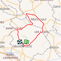
Trail Walking of 13.2 km to be discovered at Occitania, Aude, Montferrand. This trail is proposed by FLOCON.
Description
MONTFERRAND --> LES PAGES--> MONTMAUR--> SAINT LAURENT--> MONTFERRAND
BEAU TEMPS 27 RANDONNEURS
Positioning
Country:
France
Region :
Occitania
Department/Province :
Aude
Municipality :
Montferrand
Location:
Unknown
Start:(Dec)
Start:(UTM)
404547 ; 4801843 (31T) N.
Comments