


MAYRES Montlaur par la Ste Croix

raab
User
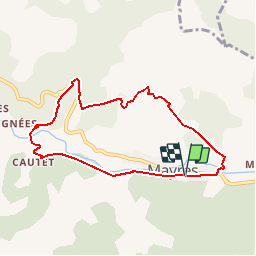

Length
7.7 km

Max alt
885 m

Uphill gradient
377 m
Km-Effort
12.7 km

Min alt
549 m

Downhill gradient
376 m
Boucle
Yes
Creation date :
2018-07-30 16:23:23.563
Updated on :
2018-07-30 16:23:23.571
2h50
Difficulty : Medium

FREE GPS app for hiking
 SityTrail
IGN / Geographical institutes
SityTrail Plus
The world is yours!
About
Trail Walking of 7.7 km to be discovered at Auvergne-Rhône-Alpes, Ardèche, Mayres. This trail is proposed by raab.
Positioning
Country:
France
Region :
Auvergne-Rhône-Alpes
Department/Province :
Ardèche
Municipality :
Mayres
Location:
Unknown
Start:(Dec)
Start:(UTM)
588499 ; 4946380 (31T) N.
Comments