Trail Walking Sagy - Vallée de l'Aubette - Sagy - Photo

Vallée de l'Aubette - Sagy

 Mars77
Mars77

User

© OpenStreetMap contributors
Length
Length
23 km
Max alt
Max alt
104 m
Uphill gradient
Uphill gradient
298 m
Km-Effort
Km-Effort  
27 km
Min alt
Min alt
42 m
Downhill gradient
Downhill gradient
297 m
Boucle
Boucle
Yes
Creation date :
2018-10-26 17:23:25.577
Updated on :
2018-10-26 17:23:25.577

(0 Reviews)

Walking
Walking
5h52
Difficulty : Medium

Scan this QR Code to open this trail in the SityTrail application

FREE GPS app for hiking

Logo SityTrail SityTrail

IGN / Geographical institutes

Download SityTrail from the App Store Download SityTrail from Google Play

Logo SityTrail SityTrail World

The world is yours!

Download SityTrail from the App Store Download SityTrail from Google Play Download SityTrail on Huawei AppGallery

About

Trail Walking of 23 km to be discovered at Ile-de-France, Val-d'Oise, Sagy. This trail is proposed by Mars77.

Elevation profile

Positioning

Country:
France
Region :
Ile-de-France
Department/Province :
Val-d'Oise
Municipality :
Sagy
Location:
Unknown
Start:(UTM)
423453 ; 5433428 (31U) N.

Trails nearby

Trail Walking Théméricourt - Théméricourt - La vallée de l''Aubette - Photo
Walking
marcel.F

Walking

Easy
(1)
Théméricourt, Ile-de-France, Val-d'Oise, France
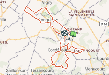
10.4 km | 12.3 km-effort
2h 42min
Yes
Trail Walking Vigny - Ligny - Photo
Walking
avdem

Walking

Easy
Vigny, Ile-de-France, Val-d'Oise, France
9.2 km | 11 km-effort
2h 8min
Yes
Trail Walking Gaillon-sur-Montcient - En passant par Dalibray - Photo
Walking
Fky78

Walking

Difficult
Gaillon-sur-Montcient, Ile-de-France, Yvelines, France
10.1 km | 12.8 km-effort
2h 34min
Yes
Trail Cycle Vigny - De Vigny à Dieppe et retour en 4 jours - Photo
Cycle
tracegps

Cycle

Medium
Vigny, Ile-de-France, Val-d'Oise, France
278 km | 310 km-effort
20h 0min
Yes
Trail Mountain bike Vauréal - Berges de l'Oise de Vauréal - Axe Majeur à St Ouen l'Aumône - Photo
Mountain bike
tracegps

Mountain bike

Easy
Vauréal, Ile-de-France, Val-d'Oise, France
25 km | 28 km-effort
1h 45min
Yes
Trail Walking Vauréal - Berges de l'Oise de Vauréal - Axe Majeur à St Ouen l'Aumône - Photo
Walking
tracegps

Walking

Medium
Vauréal, Ile-de-France, Val-d'Oise, France
25 km | 28 km-effort
5h 30min
Yes
Trail Walking Condécourt - Condécourt  - Photo
Walking
tbrunet

Walking

Very easy
Condécourt, Ile-de-France, Val-d'Oise, France
10.7 km | 12 km-effort
3h 37min
Yes
Trail Other activity Théméricourt - themericourt 001 - Photo
Other activity
dufland

Other activity

Very easy
Théméricourt, Ile-de-France, Val-d'Oise, France
21 km | 24 km-effort
5h 20min
Yes
Trail Walking Théméricourt - themericourt 01 - Photo
Walking
dufland

Walking

Easy
Théméricourt, Ile-de-France, Val-d'Oise, France
20 km | 24 km-effort
5h 14min
Yes


Close
My subscriptions