


CAP AUTOUR MTB 01 05

ramsay
User
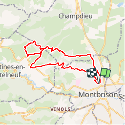

Length
14.9 km

Max alt
670 m

Uphill gradient
394 m
Km-Effort
20 km

Min alt
385 m

Downhill gradient
393 m
Boucle
Yes
Creation date :
2018-06-26 12:46:52.757
Updated on :
2018-06-26 12:46:52.757
1h30
Difficulty : Unknown

FREE GPS app for hiking
 SityTrail
IGN / Geographical institutes
SityTrail Plus
The world is yours!
About
Trail Running of 14.9 km to be discovered at Auvergne-Rhône-Alpes, Loire, Montbrison. This trail is proposed by ramsay.
Positioning
Country:
France
Region :
Auvergne-Rhône-Alpes
Department/Province :
Loire
Municipality :
Montbrison
Location:
Unknown
Start:(Dec)
Start:(UTM)
582920 ; 5051558 (31T) N.
Comments