


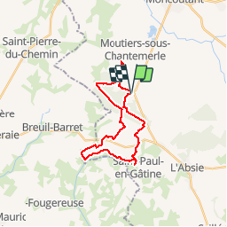
rando des muguets

dudu85
User

Length
24 km

Max alt
238 m

Uphill gradient
342 m
Km-Effort
28 km

Min alt
131 m

Downhill gradient
342 m
Boucle
Yes
Creation date :
2018-06-26 12:53:17.912
Updated on :
2018-06-26 12:53:17.912
4h36
Difficulty : Easy

FREE GPS app for hiking
 SityTrail
IGN / Geographical institutes
SityTrail Plus
The world is yours!
About
Trail Other activity of 24 km to be discovered at New Aquitaine, Deux-Sèvres, Moncoutant-sur-Sèvre. This trail is proposed by dudu85.
Positioning
Country:
France
Region :
New Aquitaine
Department/Province :
Deux-Sèvres
Municipality :
Moncoutant-sur-Sèvre
Location:
Moutiers-sous-Chantemerle
Start:(Dec)
Start:(UTM)
681982 ; 5171467 (30T) N.
Comments