


Cassis - Sormiou

DaVinci
User
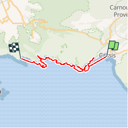

Length
21 km

Max alt
45 m

Uphill gradient
296 m
Km-Effort
25 km

Min alt
-6 m

Downhill gradient
295 m
Boucle
No
Creation date :
2018-06-26 12:55:56.814
Updated on :
2018-06-26 12:55:56.814
4h07
Difficulty : Unknown

FREE GPS app for hiking
 SityTrail
IGN / Geographical institutes
SityTrail Plus
The world is yours!
About
Trail Other activity of 21 km to be discovered at Provence-Alpes-Côte d'Azur, Bouches-du-Rhône, Cassis. This trail is proposed by DaVinci.
Positioning
Country:
France
Region :
Provence-Alpes-Côte d'Azur
Department/Province :
Bouches-du-Rhône
Municipality :
Cassis
Location:
Unknown
Start:(Dec)
Start:(UTM)
706194 ; 4787472 (31T) N.
Comments