


SVG 180501

randodan
User
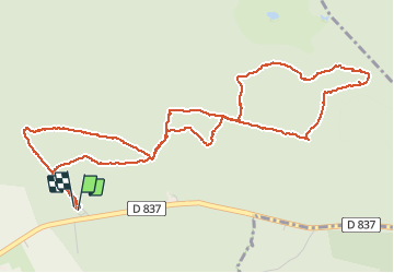

Length
6.3 km

Max alt
122 m

Uphill gradient
119 m
Km-Effort
7.9 km

Min alt
72 m

Downhill gradient
118 m
Boucle
Yes
Creation date :
2018-06-26 12:56:07.218
Updated on :
2018-06-26 12:56:07.218
3h00
Difficulty : Unknown

FREE GPS app for hiking
 SityTrail
IGN / Geographical institutes
SityTrail Plus
The world is yours!
About
Trail Walking of 6.3 km to be discovered at Ile-de-France, Essonne, Milly-la-Forêt. This trail is proposed by randodan.
Description
En cours
Photos


Positioning
Country:
France
Region :
Ile-de-France
Department/Province :
Essonne
Municipality :
Milly-la-Forêt
Location:
Unknown
Start:(Dec)
Start:(UTM)
463589 ; 5361468 (31U) N.
Comments