


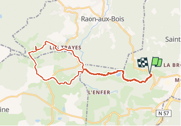
Raon aux bois

ZAMBAUX
User

Length
17.9 km

Max alt
583 m

Uphill gradient
416 m
Km-Effort
23 km

Min alt
454 m

Downhill gradient
416 m
Boucle
Yes
Creation date :
2018-06-26 12:57:54.277
Updated on :
2018-06-26 12:57:54.277
4h58
Difficulty : Medium

FREE GPS app for hiking
 SityTrail
IGN / Geographical institutes
SityTrail Plus
The world is yours!
About
Trail Walking of 17.9 km to be discovered at Grand Est, Vosges, Saint-Nabord. This trail is proposed by ZAMBAUX.


Positioning
Country:
France
Region :
Grand Est
Department/Province :
Vosges
Municipality :
Saint-Nabord
Location:
Unknown
Start:(Dec)
Start:(UTM)
317630 ; 5322724 (32U) N.
Comments