


Frère Joseph_11kms

ZAMBAUX
User
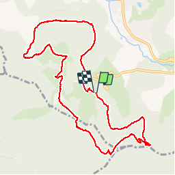

Length
11 km

Max alt
1070 m

Uphill gradient
391 m
Km-Effort
16.2 km

Min alt
755 m

Downhill gradient
389 m
Boucle
Yes
Creation date :
2019-04-27 09:34:33.487
Updated on :
2019-04-27 09:34:33.549
3h33
Difficulty : Unknown

FREE GPS app for hiking
 SityTrail
IGN / Geographical institutes
SityTrail Plus
The world is yours!
About
Trail Walking of 11 km to be discovered at Grand Est, Vosges, Ventron. This trail is proposed by ZAMBAUX.


Positioning
Country:
France
Region :
Grand Est
Department/Province :
Vosges
Municipality :
Ventron
Location:
Unknown
Start:(Dec)
Start:(UTM)
340533 ; 5310119 (32T) N.
Comments