


Circuit n° 1

dudu85
User

Length
43 km

Max alt
235 m

Uphill gradient
357 m
Km-Effort
47 km

Min alt
162 m

Downhill gradient
357 m
Boucle
Yes
Creation date :
2018-06-26 13:06:38.251
Updated on :
2018-06-26 13:06:38.251
2h44
Difficulty : Unknown

FREE GPS app for hiking
 SityTrail
IGN / Geographical institutes
SityTrail Plus
The world is yours!
About
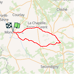
Trail Cycle of 43 km to be discovered at New Aquitaine, Deux-Sèvres, Moncoutant-sur-Sèvre. This trail is proposed by dudu85.
Positioning
Country:
France
Region :
New Aquitaine
Department/Province :
Deux-Sèvres
Municipality :
Moncoutant-sur-Sèvre
Location:
Unknown
Start:(Dec)
Start:(UTM)
684151 ; 5177259 (30T) N.
Comments