


Chantilly

Francine
User
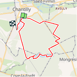

Length
15.1 km

Max alt
91 m

Uphill gradient
137 m
Km-Effort
16.9 km

Min alt
45 m

Downhill gradient
131 m
Boucle
No
Creation date :
2018-06-26 13:10:28.226
Updated on :
2018-06-26 13:10:28.226
3h00
Difficulty : Easy

FREE GPS app for hiking
 SityTrail
IGN / Geographical institutes
SityTrail Plus
The world is yours!
About
Trail Nordic walking of 15.1 km to be discovered at Hauts-de-France, Oise, Chantilly. This trail is proposed by Francine.
Description
chantilly
Positioning
Country:
France
Region :
Hauts-de-France
Department/Province :
Oise
Municipality :
Chantilly
Location:
Unknown
Start:(Dec)
Start:(UTM)
460922 ; 5447871 (31U) N.
Comments