


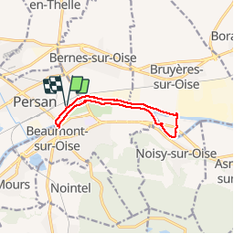
les berges de l'Oise

anonymous_fa1aecfc15
User

Length
9.2 km

Max alt
33 m

Uphill gradient
43 m
Km-Effort
9.8 km

Min alt
19 m

Downhill gradient
43 m
Boucle
Yes
Creation date :
2018-06-26 13:12:36.709
Updated on :
2018-06-26 13:12:36.709
2h13
Difficulty : Very easy

FREE GPS app for hiking
 SityTrail
IGN / Geographical institutes
SityTrail Plus
The world is yours!
About
Trail Other activity of 9.2 km to be discovered at Ile-de-France, Val-d'Oise, Persan. This trail is proposed by anonymous_fa1aecfc15.
Description
Promenade sympa le long de l'Oise
Photos


Positioning
Country:
France
Region :
Ile-de-France
Department/Province :
Val-d'Oise
Municipality :
Persan
Location:
Unknown
Start:(Dec)
Start:(UTM)
448137 ; 5444382 (31U) N.
Comments