


Le Heaulme

tarl01
User
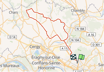

Length
67 km

Max alt
187 m

Uphill gradient
737 m
Km-Effort
77 km

Min alt
23 m

Downhill gradient
737 m
Boucle
Yes
Creation date :
2018-06-26 13:19:00.265
Updated on :
2018-06-26 13:19:00.265
3h40
Difficulty : Unknown

FREE GPS app for hiking
 SityTrail
IGN / Geographical institutes
SityTrail Plus
The world is yours!
About
Trail Cycle of 67 km to be discovered at Ile-de-France, Val-d'Oise, Le Plessis-Bouchard. This trail is proposed by tarl01.


Positioning
Country:
France
Region :
Ile-de-France
Department/Province :
Val-d'Oise
Municipality :
Le Plessis-Bouchard
Location:
Unknown
Start:(Dec)
Start:(UTM)
444610 ; 5427696 (31U) N.
Comments