


pas de l'allier

guyzinz
User

Length
17.5 km

Max alt
1279 m

Uphill gradient
1152 m
Km-Effort
33 km

Min alt
306 m

Downhill gradient
1170 m
Boucle
Yes
Creation date :
2019-06-07 09:39:03.65
Updated on :
2019-06-07 09:39:03.97
6h54
Difficulty : Unknown

FREE GPS app for hiking
 SityTrail
IGN / Geographical institutes
SityTrail Plus
The world is yours!
About
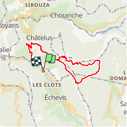
Trail Walking of 17.5 km to be discovered at Auvergne-Rhône-Alpes, Isère, Châtelus. This trail is proposed by guyzinz.
Description
depart "pont d'echevis" montée vers mezelier pas des voutes rochers du bournillon pas de l'allier retour sur pont d'echevis en passant par mezelier
Positioning
Country:
France
Region :
Auvergne-Rhône-Alpes
Department/Province :
Isère
Municipality :
Châtelus
Location:
Unknown
Start:(Dec)
Start:(UTM)
687161 ; 4990169 (31T) N.
Comments