


gr10b Trace GPS de Estérençuby à Etsaut (Pyrénées-Atlantiques)

tigrou31
User
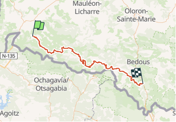

Length
107 km

Max alt
1943 m

Uphill gradient
6121 m
Km-Effort
188 km

Min alt
237 m

Downhill gradient
5709 m
Boucle
No
Creation date :
2018-06-26 13:22:33.853
Updated on :
2018-06-26 13:22:33.853
--
Difficulty : Unknown

FREE GPS app for hiking
 SityTrail
IGN / Geographical institutes
SityTrail Plus
The world is yours!
About
Trail Walking of 107 km to be discovered at New Aquitaine, Pyrénées-Atlantiques, Estérençuby. This trail is proposed by tigrou31.
Description
gr10bTrace GPSde Estérençuby à Etsaut (Pyrénées-Atlantiques)
Positioning
Country:
France
Region :
New Aquitaine
Department/Province :
Pyrénées-Atlantiques
Municipality :
Estérençuby
Location:
Unknown
Start:(Dec)
Start:(UTM)
646815 ; 4773972 (30T) N.
Comments