


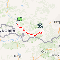
Trace GPS de Mérens-les-Vals (Pyrénées Ariègeoises) à Ras des Cortalets (Pyrénées Orientales)

tigrou31
User

Length
97 km

Max alt
2484 m

Uphill gradient
6164 m
Km-Effort
176 km

Min alt
934 m

Downhill gradient
5174 m
Boucle
No
Creation date :
2018-06-26 13:22:40.004
Updated on :
2018-06-26 13:22:40.004
34h23
Difficulty : Unknown

FREE GPS app for hiking
 SityTrail
IGN / Geographical institutes
SityTrail Plus
The world is yours!
About
Trail Walking of 97 km to be discovered at Occitania, Ariège, Mérens-les-Vals. This trail is proposed by tigrou31.
Description
Trace GPSde Mérens-les-Vals (Pyrénées Ariègeoises) à Ras des Cortalets (Pyrénées Orientales)
Positioning
Country:
France
Region :
Occitania
Department/Province :
Ariège
Municipality :
Mérens-les-Vals
Location:
Unknown
Start:(Dec)
Start:(UTM)
404609 ; 4723326 (31T) N.
Comments