


Dieudonné en Thelle 14.8 km

GOELERANDO2
User
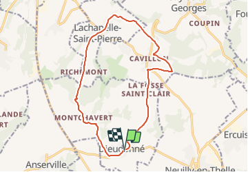

Length
14.8 km

Max alt
199 m

Uphill gradient
161 m
Km-Effort
17 km

Min alt
73 m

Downhill gradient
158 m
Boucle
Yes
Creation date :
2018-06-26 13:24:14.079
Updated on :
2018-06-26 13:24:14.079
3h43
Difficulty : Difficult

FREE GPS app for hiking
 SityTrail
IGN / Geographical institutes
SityTrail Plus
The world is yours!
About
Trail Walking of 14.8 km to be discovered at Hauts-de-France, Oise, Dieudonné. This trail is proposed by GOELERANDO2.
Description
Parking et départ de la Mairie de Dieudonné.
Positioning
Country:
France
Region :
Hauts-de-France
Department/Province :
Oise
Municipality :
Dieudonné
Location:
Unknown
Start:(Dec)
Start:(UTM)
445260 ; 5453348 (31U) N.
Comments