


Compreignac

ludol
User
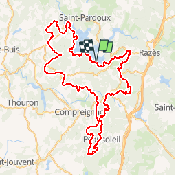

Length
48 km

Max alt
579 m

Uphill gradient
1061 m
Km-Effort
62 km

Min alt
346 m

Downhill gradient
1056 m
Boucle
Yes
Creation date :
2018-06-26 13:25:50.57
Updated on :
2018-06-26 13:25:50.57
3h12
Difficulty : Difficult

FREE GPS app for hiking
 SityTrail
IGN / Geographical institutes
SityTrail Plus
The world is yours!
About
Trail Mountain bike of 48 km to be discovered at New Aquitaine, Haute-Vienne, Compreignac. This trail is proposed by ludol.
Description
Simplification
Positioning
Country:
France
Region :
New Aquitaine
Department/Province :
Haute-Vienne
Municipality :
Compreignac
Location:
Unknown
Start:(Dec)
Start:(UTM)
367836 ; 5098424 (31T) N.
Comments