


Breuil le Sec cc

Francine
User
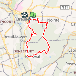

Length
11.6 km

Max alt
162 m

Uphill gradient
214 m
Km-Effort
14.5 km

Min alt
46 m

Downhill gradient
214 m
Boucle
Yes
Creation date :
2018-06-26 13:27:24.043
Updated on :
2018-06-26 13:27:24.043
3h07
Difficulty : Difficult

FREE GPS app for hiking
 SityTrail
IGN / Geographical institutes
SityTrail Plus
The world is yours!
About
Trail Walking of 11.6 km to be discovered at Hauts-de-France, Oise, Breuil-le-Sec. This trail is proposed by Francine.
Description
Breuil le Sec
Positioning
Country:
France
Region :
Hauts-de-France
Department/Province :
Oise
Municipality :
Breuil-le-Sec
Location:
Unknown
Start:(Dec)
Start:(UTM)
460294 ; 5469166 (31U) N.
Comments