


cantal plomb les gardes

coglais
User
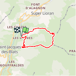

Length
10.5 km

Max alt
1831 m

Uphill gradient
722 m
Km-Effort
20 km

Min alt
1126 m

Downhill gradient
719 m
Boucle
Yes
Creation date :
2018-06-26 13:32:47.709
Updated on :
2018-06-26 13:32:47.709
5h00
Difficulty : Unknown

FREE GPS app for hiking
 SityTrail
IGN / Geographical institutes
SityTrail Plus
The world is yours!
About
Trail Nordic walking of 10.5 km to be discovered at Auvergne-Rhône-Alpes, Cantal, Saint-Jacques-des-Blats. This trail is proposed by coglais.
Positioning
Country:
France
Region :
Auvergne-Rhône-Alpes
Department/Province :
Cantal
Municipality :
Saint-Jacques-des-Blats
Location:
Unknown
Start:(Dec)
Start:(UTM)
478354 ; 4990071 (31T) N.
Comments