


Château-Thierry Côte 204 10 km

GOELERANDO2
User
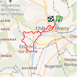

Length
10 km

Max alt
190 m

Uphill gradient
181 m
Km-Effort
12.4 km

Min alt
55 m

Downhill gradient
186 m
Boucle
Yes
Creation date :
2018-06-26 13:57:20.823
Updated on :
2018-06-26 13:57:20.823
2h42
Difficulty : Medium

FREE GPS app for hiking
 SityTrail
IGN / Geographical institutes
SityTrail Plus
The world is yours!
About
Trail Walking of 10 km to be discovered at Hauts-de-France, Aisne, Château-Thierry. This trail is proposed by GOELERANDO2.
Description
Parking et départ du Château.
Positioning
Country:
France
Region :
Hauts-de-France
Department/Province :
Aisne
Municipality :
Château-Thierry
Location:
Unknown
Start:(Dec)
Start:(UTM)
529669 ; 5432855 (31U) N.
Comments