


LANGOGNE201JOUR2

ramsay
User
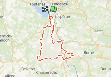

Length
71 km

Max alt
1487 m

Uphill gradient
1903 m
Km-Effort
96 km

Min alt
909 m

Downhill gradient
1908 m
Boucle
Yes
Creation date :
2018-06-26 14:03:06.588
Updated on :
2018-06-26 14:03:06.588
5h57
Difficulty : Medium

FREE GPS app for hiking
 SityTrail
IGN / Geographical institutes
SityTrail Plus
The world is yours!
About
Trail Mountain bike of 71 km to be discovered at Occitania, Lozère, Langogne. This trail is proposed by ramsay.
Positioning
Country:
France
Region :
Occitania
Department/Province :
Lozère
Municipality :
Langogne
Location:
Unknown
Start:(Dec)
Start:(UTM)
566517 ; 4953568 (31T) N.
Comments