Trail Other activity Us - tour d us - Photo
 avdem
avdem

User

© OpenStreetMap contributors
Length
Length
19.4 km
Max alt
Max alt
114 m
Uphill gradient
Uphill gradient
256 m
Km-Effort
Km-Effort  
23 km
Min alt
Min alt
45 m
Downhill gradient
Downhill gradient
256 m
Boucle
Boucle
Yes
Creation date :
2018-06-26 14:12:03.676
Updated on :
2018-06-26 14:12:03.676

(0 Reviews)

Other activity
Other activity
5h31
Difficulty : Difficult

Scan this QR Code to open this trail in the SityTrail application

FREE GPS app for hiking

Logo SityTrail SityTrail

IGN / Geographical institutes

Download SityTrail from the App Store Download SityTrail from Google Play

Logo SityTrail SityTrail World

The world is yours!

Download SityTrail from the App Store Download SityTrail from Google Play Download SityTrail on Huawei AppGallery

About

Trail Other activity of 19.4 km to be discovered at Ile-de-France, Val-d'Oise, Us. This trail is proposed by avdem.

Description

grand tour d Us entre César et Brunchaut

Elevation profile

Positioning

Country:
France
Region :
Ile-de-France
Department/Province :
Val-d'Oise
Municipality :
Us
Location:
Unknown
Start:(UTM)
424899 ; 5439042 (31U) N.

Trails nearby

Trail Walking Bréançon - De Bréançon à Neuville Bosc - Photo
Walking
tracegps

Walking

Medium
(2)
Bréançon, Ile-de-France, Val-d'Oise, France
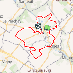
18.9 km | 24 km-effort
4h 30min
Yes
Trail Walking Le Perchay - le perchay etang de valliere santeuil - Photo
Walking
jeang95

Walking

Very easy
(2)
Le Perchay, Ile-de-France, Val-d'Oise, France
6.9 km | 8.1 km-effort
1h 34min
Yes
Trail Walking Bréançon - Bréançon RDA 13k - Photo
Walking
dufland

Walking

Easy
(1)
Bréançon, Ile-de-France, Val-d'Oise, France
12.9 km | 16.1 km-effort
3h 27min
Yes
Trail Walking Bréançon - breançon le haulme - Photo
Walking
laurentbernardbrunel

Walking

Medium
(1)
Bréançon, Ile-de-France, Val-d'Oise, France
9.9 km | 12.1 km-effort
1h 58min
Yes
Trail Walking Us - US - La chaussée Brunehaut - Photo
Walking
marcel.F

Walking

Easy
(1)
Us, Ile-de-France, Val-d'Oise, France
11 km | 13 km-effort
2h 50min
Yes
Trail Walking Boissy-l'Aillerie - La chaussée Jules César - Photo
Walking
ppeul

Walking

Very easy
(2)
Boissy-l'Aillerie, Ile-de-France, Val-d'Oise, France
10.9 km | 13.9 km-effort
Unknown
Yes
Trail Walking Vigny - Ligny - Photo
Walking
avdem

Walking

Easy
Vigny, Ile-de-France, Val-d'Oise, France
9.2 km | 11 km-effort
2h 8min
Yes
Trail Walking Moussy - Moussy - Photo
Walking
Fky78

Walking

Medium
(1)
Moussy, Ile-de-France, Val-d'Oise, France
8.8 km | 10.2 km-effort
2h 18min
Yes
Trail On foot Santeuil - Le tour du Grand Paris via le GR1 - Etape 4  - Photo
On foot
chessyca

On foot

Difficult
Santeuil, Ile-de-France, Val-d'Oise, France
34 km | 39 km-effort
8h 58min
No


Close
My subscriptions