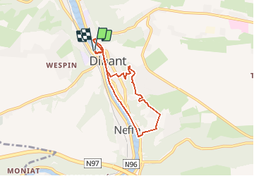
Trail Walking Dinant - Balade à Dinant - Photo

Balade à Dinant

 Desrumaux
Desrumaux

User GUIDE

© OpenStreetMap contributors
Length
Length
5.6 km
Max alt
Max alt
234 m
Uphill gradient
Uphill gradient
180 m
Km-Effort
Km-Effort  
8 km
Min alt
Min alt
90 m
Downhill gradient
Downhill gradient
179 m
Boucle
Boucle
Yes
Creation date :
2018-06-26 14:18:29.141
Updated on :
2018-06-26 14:18:29.141

(0 Reviews)

Walking
Walking
2h00
Difficulty : Easy

Scan this QR Code to open this trail in the SityTrail application

FREE GPS app for hiking

Logo SityTrail SityTrail

IGN / Geographical institutes

Download SityTrail from the App Store Download SityTrail from Google Play

Logo SityTrail SityTrail Plus

The world is yours!

Download SityTrail from the App Store Download SityTrail from Google Play Download SityTrail on Huawei AppGallery

About

Trail Walking of 5.6 km to be discovered at Wallonia, Namur, Dinant. This trail is proposed by Desrumaux.

Description


Jolie balade à Dinant au départ de la Croisette jusqu'au quartier Saint  Paul par le sentier des crêtes.
Départ: Maison du Tourisme - Avenue Colonel Cadoux.
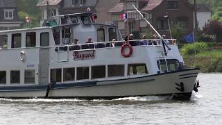


Elevation profile

Photos

Points of interest

Point of interest Dinant - Dinant - Photo
Desrumaux
DINANT 
Point of interest Dinant - Dinant - Photo
Desrumaux
DINANT 
Point of interest Dinant - Dinant - Photo
Desrumaux
DINANT 
Point of interest Dinant - Dinant - Photo
Desrumaux
DINANT 
Point of interest Dinant - Dinant - Photo
Desrumaux
DINANT 

Positioning

Country:
Belgium
Region :
Wallonia
Department/Province :
Namur
Municipality :
Dinant
Location:
Dinant
Start:(UTM)
636141 ; 5569366 (31U) N.


Close
My subscriptions