


MAISSE - LA FERTE ALAIS PAR BOUTIGNY (IBP 64)

NUITEVEN
User
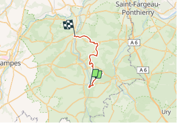

Length
23 km

Max alt
146 m

Uphill gradient
298 m
Km-Effort
27 km

Min alt
62 m

Downhill gradient
297 m
Boucle
No
Creation date :
2018-06-26 14:25:08.775
Updated on :
2018-06-26 14:25:08.775
5h59
Difficulty : Easy

FREE GPS app for hiking
 SityTrail
IGN / Geographical institutes
SityTrail Plus
The world is yours!
About
Trail Walking of 23 km to be discovered at Ile-de-France, Essonne, Maisse. This trail is proposed by NUITEVEN.
Positioning
Country:
France
Region :
Ile-de-France
Department/Province :
Essonne
Municipality :
Maisse
Location:
Unknown
Start:(Dec)
Start:(UTM)
455069 ; 5360154 (31U) N.
Comments