


Meteren Becque

dehemjacques
User
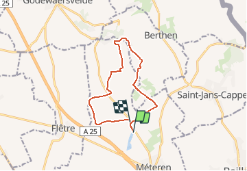

Length
10.5 km

Max alt
126 m

Uphill gradient
163 m
Km-Effort
12.7 km

Min alt
28 m

Downhill gradient
161 m
Boucle
No
Creation date :
2018-06-26 14:31:57.505
Updated on :
2018-06-26 14:31:57.505
2h44
Difficulty : Easy

FREE GPS app for hiking
 SityTrail
IGN / Geographical institutes
SityTrail Plus
The world is yours!
About
Trail Walking of 10.5 km to be discovered at Hauts-de-France, Nord, Méteren. This trail is proposed by dehemjacques.
Description
départ de l'étang des 4 fils Aymon de Méteren
Positioning
Country:
France
Region :
Hauts-de-France
Department/Province :
Nord
Municipality :
Méteren
Location:
Unknown
Start:(Dec)
Start:(UTM)
477502 ; 5622306 (31U) N.
Comments