


Joinville_hauteurs_et_ville

Jeff_314
User
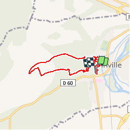

Length
7.5 km

Max alt
322 m

Uphill gradient
238 m
Km-Effort
10.7 km

Min alt
184 m

Downhill gradient
244 m
Boucle
Yes
Creation date :
2014-12-10 00:00:00.0
Updated on :
2014-12-10 00:00:00.0
2h14
Difficulty : Easy

FREE GPS app for hiking
 SityTrail
IGN / Geographical institutes
SityTrail Plus
The world is yours!
About
Trail Walking of 7.5 km to be discovered at Grand Est, Haute-Marne, Joinville. This trail is proposed by Jeff_314.
Description
Ballade sur les hauteurs et dans la ville de Joinville
Positioning
Country:
France
Region :
Grand Est
Department/Province :
Haute-Marne
Municipality :
Joinville
Location:
Unknown
Start:(Dec)
Start:(UTM)
658055 ; 5367514 (31U) N.
Comments