


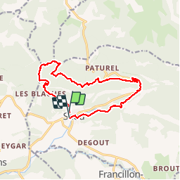
Roche Colombe - Saou

okfred26
User

Length
14.3 km

Max alt
874 m

Uphill gradient
652 m
Km-Effort
23 km

Min alt
325 m

Downhill gradient
659 m
Boucle
Yes
Creation date :
2018-06-26 14:35:03.353
Updated on :
2018-06-26 14:35:03.353
4h12
Difficulty : Easy

FREE GPS app for hiking
 SityTrail
IGN / Geographical institutes
SityTrail Plus
The world is yours!
About
Trail Walking of 14.3 km to be discovered at Auvergne-Rhône-Alpes, Drôme, Saou. This trail is proposed by okfred26.
Positioning
Country:
France
Region :
Auvergne-Rhône-Alpes
Department/Province :
Drôme
Municipality :
Saou
Location:
Unknown
Start:(Dec)
Start:(UTM)
663392 ; 4945755 (31T) N.
Comments