


Galaxy Note 2 Berg avec Saint-Pierre de Colombier

raab
User
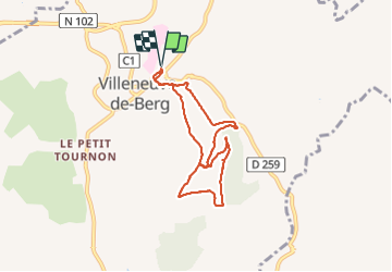

Length
7.2 km

Max alt
454 m

Uphill gradient
237 m
Km-Effort
10.4 km

Min alt
294 m

Downhill gradient
238 m
Boucle
Yes
Creation date :
2018-07-30 16:23:22.151
Updated on :
2021-10-28 17:48:37.996
2h17
Difficulty : Easy

FREE GPS app for hiking
 SityTrail
IGN / Geographical institutes
SityTrail Plus
The world is yours!
About
Trail Walking of 7.2 km to be discovered at Auvergne-Rhône-Alpes, Ardèche, Villeneuve-de-Berg. This trail is proposed by raab.
Positioning
Country:
France
Region :
Auvergne-Rhône-Alpes
Department/Province :
Ardèche
Municipality :
Villeneuve-de-Berg
Location:
Unknown
Start:(Dec)
Start:(UTM)
619282 ; 4935009 (31T) N.
Comments