


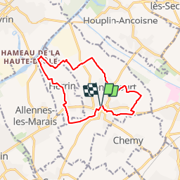
Gondecourt bis 12 km

Blourouce
User

Length
12.1 km

Max alt
27 m

Uphill gradient
46 m
Km-Effort
12.7 km

Min alt
15 m

Downhill gradient
46 m
Boucle
Yes
Creation date :
2019-01-12 16:54:15.041
Updated on :
2019-01-12 16:54:15.275
2h50
Difficulty : Unknown

FREE GPS app for hiking
 SityTrail
IGN / Geographical institutes
SityTrail Plus
The world is yours!
About
Trail Walking of 12.1 km to be discovered at Hauts-de-France, Nord, Gondecourt. This trail is proposed by Blourouce.
Positioning
Country:
France
Region :
Hauts-de-France
Department/Province :
Nord
Municipality :
Gondecourt
Location:
Unknown
Start:(Dec)
Start:(UTM)
498793 ; 5599054 (31U) N.
Comments