


W - 2018 - 23 Montoillot Commarin

clabidault
User
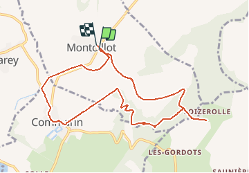

Length
9.9 km

Max alt
556 m

Uphill gradient
227 m
Km-Effort
12.9 km

Min alt
370 m

Downhill gradient
223 m
Boucle
Yes
Creation date :
2018-06-26 14:57:20.326
Updated on :
2018-12-31 14:16:50.957
2h45
Difficulty : Medium

FREE GPS app for hiking
 SityTrail
IGN / Geographical institutes
SityTrail Plus
The world is yours!
About
Trail Walking of 9.9 km to be discovered at Bourgogne-Franche-Comté, Côte-d'Or, Montoillot. This trail is proposed by clabidault.
Description
13 Participants petit soleil
liaison Panthier Montoillot en voiture
Positioning
Country:
France
Region :
Bourgogne-Franche-Comté
Department/Province :
Côte-d'Or
Municipality :
Montoillot
Location:
Unknown
Start:(Dec)
Start:(UTM)
625482 ; 5236388 (31T) N.
Comments