


campo vrai

UDGI54
User

Length
33 km

Max alt
202 m

Uphill gradient
655 m
Km-Effort
42 km

Min alt
46 m

Downhill gradient
656 m
Boucle
Yes
Creation date :
2018-06-26 15:15:27.353
Updated on :
2018-06-26 15:15:27.353
6h00
Difficulty : Difficult

FREE GPS app for hiking
 SityTrail
IGN / Geographical institutes
SityTrail Plus
The world is yours!
About
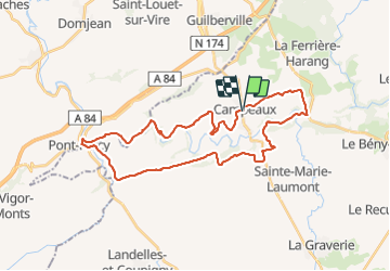
Trail Walking of 33 km to be discovered at Normandy, Calvados, Souleuvre-en-Bocage. This trail is proposed by UDGI54.
Positioning
Country:
France
Region :
Normandy
Department/Province :
Calvados
Municipality :
Souleuvre-en-Bocage
Location:
Campeaux
Start:(Dec)
Start:(UTM)
651478 ; 5424028 (30U) N.
Comments