


Fosseuse

avdem
User
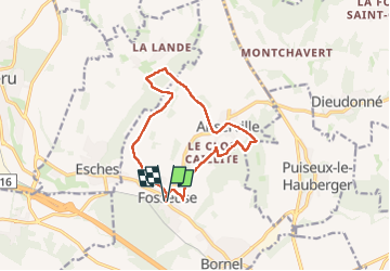

Length
11.5 km

Max alt
145 m

Uphill gradient
177 m
Km-Effort
13.9 km

Min alt
55 m

Downhill gradient
176 m
Boucle
Yes
Creation date :
2018-06-26 15:16:26.906
Updated on :
2018-06-26 15:16:26.906
2h49
Difficulty : Unknown

FREE GPS app for hiking
 SityTrail
IGN / Geographical institutes
SityTrail Plus
The world is yours!
About
Trail Other activity of 11.5 km to be discovered at Hauts-de-France, Oise, Bornel. This trail is proposed by avdem.
Description
tour
Positioning
Country:
France
Region :
Hauts-de-France
Department/Province :
Oise
Municipality :
Bornel
Location:
Unknown
Start:(Dec)
Start:(UTM)
440979 ; 5451184 (31U) N.
Comments