


Bouillon Trek Atour J2

libertju
User
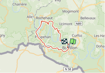

Length
21 km

Max alt
390 m

Uphill gradient
844 m
Km-Effort
32 km

Min alt
194 m

Downhill gradient
844 m
Boucle
Yes
Creation date :
2018-08-19 08:46:03.643
Updated on :
2024-04-09 09:32:47.909
8h20
Difficulty : Unknown

FREE GPS app for hiking
 SityTrail
IGN / Geographical institutes
SityTrail Plus
The world is yours!
About
Trail Other activity of 21 km to be discovered at Wallonia, Luxembourg, Bouillon. This trail is proposed by libertju.
Positioning
Country:
Belgium
Region :
Wallonia
Department/Province :
Luxembourg
Municipality :
Bouillon
Location:
Unknown
Start:(Dec)
Start:(UTM)
648639 ; 5517822 (31U) N.
Comments