


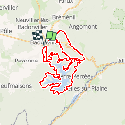
Les lacs de Badonviller 2018

nicolas54230
User

Length
45 km

Max alt
522 m

Uphill gradient
1127 m
Km-Effort
60 km

Min alt
312 m

Downhill gradient
1128 m
Boucle
Yes
Creation date :
2018-06-26 15:30:41.165
Updated on :
2018-06-26 15:30:41.165
3h39
Difficulty : Medium

FREE GPS app for hiking
 SityTrail
IGN / Geographical institutes
SityTrail Plus
The world is yours!
About
Trail Mountain bike of 45 km to be discovered at Grand Est, Meurthe-et-Moselle, Badonviller. This trail is proposed by nicolas54230.
Positioning
Country:
France
Region :
Grand Est
Department/Province :
Meurthe-et-Moselle
Municipality :
Badonviller
Location:
Unknown
Start:(Dec)
Start:(UTM)
344337 ; 5373622 (32U) N.
Comments