


Crosne/Yerres

gdela
User
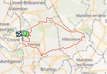

Length
16.4 km

Max alt
122 m

Uphill gradient
177 m
Km-Effort
18.8 km

Min alt
36 m

Downhill gradient
174 m
Boucle
Yes
Creation date :
2018-06-26 15:39:11.614
Updated on :
2022-11-28 17:02:53.74
4h04
Difficulty : Medium

FREE GPS app for hiking
 SityTrail
IGN / Geographical institutes
SityTrail Plus
The world is yours!
About
Trail Walking of 16.4 km to be discovered at Ile-de-France, Essonne, Crosne. This trail is proposed by gdela.
Description
rando 16km
Positioning
Country:
France
Region :
Ile-de-France
Department/Province :
Essonne
Municipality :
Crosne
Location:
Unknown
Start:(Dec)
Start:(UTM)
461328 ; 5396441 (31U) N.
Comments