


Rocher Canon

gdela
User
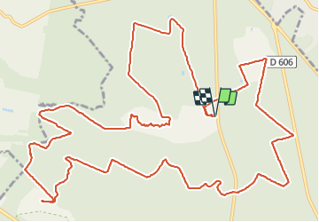

Length
18.7 km

Max alt
149 m

Uphill gradient
214 m
Km-Effort
22 km

Min alt
82 m

Downhill gradient
216 m
Boucle
Yes
Creation date :
2018-06-26 15:39:13.682
Updated on :
2018-06-26 15:39:13.682
4h41
Difficulty : Medium

FREE GPS app for hiking
 SityTrail
IGN / Geographical institutes
SityTrail Plus
The world is yours!
About
Trail Walking of 18.7 km to be discovered at Ile-de-France, Seine-et-Marne, Fontainebleau. This trail is proposed by gdela.
Description
rando 19km
Positioning
Country:
France
Region :
Ile-de-France
Department/Province :
Seine-et-Marne
Municipality :
Fontainebleau
Location:
Unknown
Start:(Dec)
Start:(UTM)
475397 ; 5367804 (31U) N.
Comments