


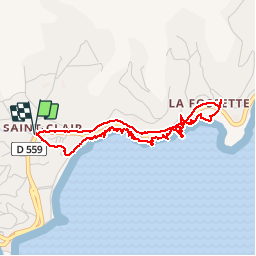
Sentier du littoral St Clair a` La Fossette et retour

henriantoine
User

Length
4.4 km

Max alt
36 m

Uphill gradient
69 m
Km-Effort
5.3 km

Min alt
0 m

Downhill gradient
69 m
Boucle
Yes
Creation date :
2018-09-11 10:15:38.114
Updated on :
2018-09-11 10:15:38.114
2h09
Difficulty : Difficult

FREE GPS app for hiking
 SityTrail
IGN / Geographical institutes
SityTrail Plus
The world is yours!
About
Trail Walking of 4.4 km to be discovered at Provence-Alpes-Côte d'Azur, Var, Le Lavandou. This trail is proposed by henriantoine.
Photos


26 photos in total. Please click on a photo to see them all in the gallery.
Positioning
Country:
France
Region :
Provence-Alpes-Côte d'Azur
Department/Province :
Var
Municipality :
Le Lavandou
Location:
Unknown
Start:(Dec)
Start:(UTM)
286927 ; 4780224 (32T) N.
Comments